Teaching Climate Zones: Polar, Temperate, & Tropical
Climate zones are the big bands of weather that wrap around the Earth. The tropical zone hugs the equator, the polar zones sit at the top and bottom, and the temperate zones fall in between.
After 13 years teaching 3rd to 5th grade, this is the two-day lesson I’d hand a teacher friend. You’ll get a globe graphic, a color-coding worksheet, a poster gallery walk, and exit slip questions you can use tomorrow.
What are the 3 climate zones?
- Tropical: near the equator. Warm all year, often rainy.
- Temperate: between the tropics and the polar zones. Four seasons, with warm summers and cool or cold winters.
- Polar: near the North and South Poles. Cold all year, with little precipitation.
Are there 3, 4, or 5 climate zones?
It depends on the map. Most elementary lessons use three zones based on distance from the equator: polar, temperate, and tropical. Some maps count the northern and southern temperate zones separately, or add a dry (desert) zone, which is where “4 climate zones” comes from. Scientists use a more detailed system called the Köppen classification. For 3rd to 5th grade, three zones is the clearest starting point. Once kids have those, show them a desert on the map and ask where it fits.

This is the third lesson in my weather unit. If you’re starting from the top, begin with teaching the types of precipitation, then weather tools and instruments. Want the whole unit at a glance? Here’s how I plan a weather and climate unit. Below, in the chart, you’ll find an estimated timeline and each of the lessons that will be covered throughout the weather unit.
| Weather Unit Lessons | Estimated Timeline |
| Types of Precipitation | Days 1 – 2 |
| Weather Tools | Day 3 – 6 |
| Climate Zones | Days 7 – 8 |
| Types of Clouds | Days 9 – 10 |
| Review Weather Unit & Assessment | Days 11 – 15 |
Materials You Need:
- Climate Zone Graphic
- Scissors
- Globe (if available)
- Colored Pencils or Crayons
- Color Code Climate Zones Worksheet (2 versions available)
Before you start, make sure kids know the difference between weather and climate. Weather is what it’s like outside today. Climate is the average weather in a place over a long time, usually 30 years or more. This lesson fits Florida’s SC.5.E.7.6 and NGSS 3-ESS2-2 (describe climates in different regions of the world).
| Essential Questions | – How do the characteristics of the polar, temperate, and tropical zones differ? – How do the climate zones shape the life that is found in each of these zones? |
| Learning Goal & Objective | – Students will be able to describe characteristics of different climate zones as they relate to latitude, elevation, and proximity to bodies of water. |
| Florida Standard | SC.5.E.7.6 Describe characteristics (temperature and precipitation) of different climate zones as they relate to latitude, elevation, and proximity to bodies of water. |
| Lesson Overview | – Climate Zone Graphic – Color Code the Climate Zones Worksheet |
| Higher Order Thinking Questions | – What makes the polar zone cold? – Why is the tropical zone warm? – If you visited each climate zone, what kind of clothes would you need to pack? – How does life in the tropical zone differ from life in the polar zone? – What is your favorite climate zone? Why? – If you could pick one climate zone to live in, which would it be and why? |
Day 7 of the Weather Unit / Day 1 of Climate Zones
Start by reviewing the hands gestures that students created on Day 1 of the weather unit. Try to do this every day of the weather unit so that you keep it fresh in the students’ minds. You can also use a climate zone map to show different climates around the world, such as those in the tropical zone, temperate zones, and polar regions.
You’ll also want to save a few minutes to do the Weather Data Collection: Compare Locations activity from yesterday’s lesson.
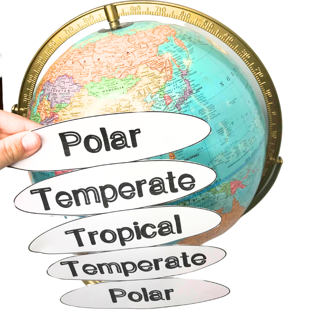
Climate Zone Graphic
Students will begin by cutting out this climate zone graphic and bending it around a globe to visualize the major climate zones of the world. This is such a great visual for students to see the different zones and what type of weather could be seen in each.
Flip over the graphic and take notes on the backside about each zone. Include notes about the temperature, precipitation, vegetation, etc. to describe each climate zone.
Color Code Climate Zone Worksheet
Give students a copy of the color code climate zones worksheet. There are two versions available here:
- 1. For the first version, students draw the world map and label the different climate zones. At the bottom, they describe the type of weather in each zone, such as cold winters in polar regions and warm weather in tropical climates.
- 2. For the second version, students color-code the sections of the climate zone map and then describe each zone.

As a way to extend this science lesson or incorporate science into your reading time, use this climate zones close reading activity. Students can read the text, answer the ten multiple choice questions, then complete some of the included graphic organizers. There are even two bookmark style checklists for close reading steps and steps to annotate a text.

Day 8 of the Weather Unit / Day 2 of Climate Zones
Give students time to interact with the information they’ve just learned. Break them into small groups and have them create a poster about a particular climate zone. This could be a fun project to showcase the climate of the places they’ve studied, using poster boards and markers. Each group can focus on different climate zones and include features like average temperature, vegetation, and wind patterns. Students will be responsible for creating a poster or anchor chart on one of the climate zones.
You can take a few minutes to list out the expectations (similar to a rubric), by asking students what they think is important to include on the poster. With student input, you can normally lead them to include these requirements: temperature, precipitation, vegetation, show where it’s located in the world, and pictures. Sometimes, the students will get super creative and include extra things like: What should you wear? and What activities could you do outside?
Lay out markers, colored pencils, and crayons. Remind students that this should be fun but they should be focused on showing what they learned about their climate zone.
After students create their own anchor charts and/or posters, have them participate in a gallery walk. Hang the posters up around the classroom, give students a few sticky notes, and circulate around the class. Students should write something positive on a sticky note for each poster they visit. Sometimes, we can do all of this in one class period, but you could easily stretch it over two class periods. This activity not only teaches about different climates but also promotes critical thinking and collaboration.
Climate Zones Exit Slip Question Ideas:
- Which climate zone is the warmest? Why?
- Which climate zone is the coldest? Why?
- Name one animal that lives in the polar zone. Why is it suited for that environment?
- If you were going on vacation, what clothes would you pack for each climate zone?
- What would need to be different about the houses built in each climate zone?
- What climate zone do you think you want to live in? Why?
Climates in Specific Biomes
If you’re looking to teach about weather in different environments like biomes, use this Weather in Different Environments Text. Students can read the text, answer the ten multiple choice questions, then complete some of the included graphic organizers. There are even two bookmark style checklists for close reading steps and steps to annotate a text. For more ways to mix reading into science, see integrating science and literacy.

Looking for an Extension Activity?
For an extension, use a climate graph to teach students about patterns in average temperature across the southern hemispheres and northern hemispheres.
Kids who finish early can look up a city on each continent and decide which climate zone it’s in. Then have them check: does the weather there match what the zone predicts?
Next up in the unit is the types of clouds.
Want the climate zones lesson ready to print?
The printables from this lesson are in my Climate Zones Activities set: the climate zone graphic and both versions of the color-coding worksheet. Print it and you’re ready for days 7 and 8.
Teaching the whole weather unit? The Weather Unit bundle has precipitation, weather tools, climate zones, and clouds in one place.
Frequently Asked Questions
Polar, temperate, and tropical. They’re grouped by how far they are from the equator, which controls how much direct sunlight they get.
The sun’s rays hit the equator most directly all year. Near the poles, the same sunlight comes in at a low angle and spreads out, so it’s much colder.
Weather is what’s happening outside today. Climate is the average weather in a place over a long time, usually 30 years or more.
It depends on your standards. NGSS covers climates in different regions in 3rd grade (3-ESS2-2), and Florida covers climate zones in 5th grade (SC.5.E.7.6).
This plan uses two class periods: one for the globe graphic and worksheet, and one for posters and a gallery walk.
Reviewing before the state test? Grab ideas from my 5th grade science standards review.
Tomorrow, grab a globe and the climate zone graphic, and let kids wrap it themselves. It’s the part they’ll remember.
Save this Science Lesson!
Pin these ideas to your favorite classroom Pinterest board. Then you can come back whenever you need ideas or inspiration!